


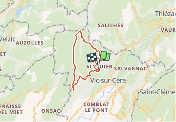
boucle aliquier vtt débutant ou rando à pied

denel
User

Length
11.6 km

Max alt
1246 m

Uphill gradient
435 m
Km-Effort
17.4 km

Min alt
851 m

Downhill gradient
435 m
Boucle
Yes
Creation date :
2020-08-01 03:48:46.653
Updated on :
2020-08-01 09:21:13.555
3h24
Difficulty : Very easy
1h40
Difficulty : Very easy

FREE GPS app for hiking
 SityTrail
IGN / Geographical institutes
SityTrail Plus
The world is yours!
About
Trail Walking of 11.6 km to be discovered at Auvergne-Rhône-Alpes, Cantal, Vic-sur-Cère. This trail is proposed by denel.
Description
Boucle au départ de aliquier en passant par l'arbre de quenouille
Positioning
Country:
France
Region :
Auvergne-Rhône-Alpes
Department/Province :
Cantal
Municipality :
Vic-sur-Cère
Location:
Unknown
Start:(Dec)
Start:(UTM)
469861 ; 4981580 (31T) N.
Comments