


Innsbruck

Arnaud Dejean
User

Length
17.2 km

Max alt
680 m

Uphill gradient
222 m
Km-Effort
19.9 km

Min alt
571 m

Downhill gradient
159 m
Boucle
No
Creation date :
2020-08-02 08:32:35.519
Updated on :
2020-08-02 10:53:53.041
2h16
Difficulty : Very easy

FREE GPS app for hiking
 SityTrail
IGN / Geographical institutes
SityTrail Plus
The world is yours!
About
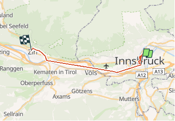
Trail Walking of 17.2 km to be discovered at Tyrol, Innsbruck, Unknown. This trail is proposed by Arnaud Dejean.
Positioning
Country:
Austria
Region :
Tyrol
Department/Province :
Innsbruck
Municipality :
Unknown
Location:
Wilten
Start:(Dec)
Start:(UTM)
681184 ; 5237064 (32T) N.
Comments