


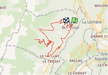
au dessus de Bonneval Tarentaise

franquen
User

Length
27 km

Max alt
1924 m

Uphill gradient
1232 m
Km-Effort
43 km

Min alt
938 m

Downhill gradient
1234 m
Boucle
Yes
Creation date :
2020-08-02 07:22:11.794
Updated on :
2020-08-02 15:03:14.381
3h06
Difficulty : Easy

FREE GPS app for hiking
 SityTrail
IGN / Geographical institutes
SityTrail Plus
The world is yours!
About
Trail Electric bike of 27 km to be discovered at Auvergne-Rhône-Alpes, Savoy, La Léchère. This trail is proposed by franquen.
Positioning
Country:
France
Region :
Auvergne-Rhône-Alpes
Department/Province :
Savoy
Municipality :
La Léchère
Location:
Unknown
Start:(Dec)
Start:(UTM)
301295 ; 5044136 (32T) N.
Comments