


Lac noir

nicogex
User
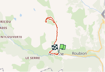

Length
13 km

Max alt
2402 m

Uphill gradient
811 m
Km-Effort
24 km

Min alt
1596 m

Downhill gradient
813 m
Boucle
Yes
Creation date :
2020-08-02 07:17:20.0
Updated on :
2020-08-02 12:29:30.617
4h12
Difficulty : Medium

FREE GPS app for hiking
 SityTrail
IGN / Geographical institutes
SityTrail Plus
The world is yours!
About
Trail Walking of 13 km to be discovered at Provence-Alpes-Côte d'Azur, Hautes-Alpes, Névache. This trail is proposed by nicogex.
Description
Lac noir hors sentier
Positioning
Country:
France
Region :
Provence-Alpes-Côte d'Azur
Department/Province :
Hautes-Alpes
Municipality :
Névache
Location:
Unknown
Start:(Dec)
Start:(UTM)
311459 ; 4987881 (32T) N.
Comments