


Pairees 20/20

fra_depoorter
User
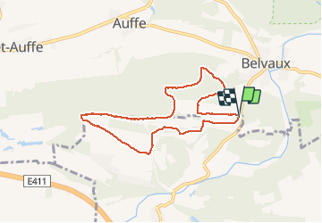

Length
7.1 km

Max alt
278 m

Uphill gradient
79 m
Km-Effort
8.1 km

Min alt
233 m

Downhill gradient
80 m
Boucle
Yes
Creation date :
2020-08-02 07:26:51.982
Updated on :
2020-08-02 16:11:18.777
1h39
Difficulty : Very easy

FREE GPS app for hiking
 SityTrail
IGN / Geographical institutes
SityTrail Plus
The world is yours!
About
Trail Walking of 7.1 km to be discovered at Wallonia, Luxembourg, Tellin. This trail is proposed by fra_depoorter.
Positioning
Country:
Belgium
Region :
Wallonia
Department/Province :
Luxembourg
Municipality :
Tellin
Location:
Resteigne
Start:(Dec)
Start:(UTM)
656492 ; 5552093 (31U) N.
Comments
top