


VARS Les Claux

d.rognon
User
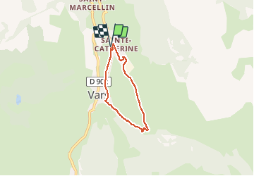

Length
4.7 km

Max alt
1897 m

Uphill gradient
211 m
Km-Effort
7.5 km

Min alt
1676 m

Downhill gradient
216 m
Boucle
Yes
Creation date :
2020-08-03 02:52:52.154
Updated on :
2020-09-23 03:56:31.453
1h32
Difficulty : Medium

FREE GPS app for hiking
 SityTrail
IGN / Geographical institutes
SityTrail Plus
The world is yours!
About
Trail Walking of 4.7 km to be discovered at Provence-Alpes-Côte d'Azur, Hautes-Alpes, Vars. This trail is proposed by d.rognon.
Positioning
Country:
France
Region :
Provence-Alpes-Côte d'Azur
Department/Province :
Hautes-Alpes
Municipality :
Vars
Location:
Unknown
Start:(Dec)
Start:(UTM)
316924 ; 4941349 (32T) N.
Comments