


Ymare - Version 2020 -9 km

MichelRando7656
User
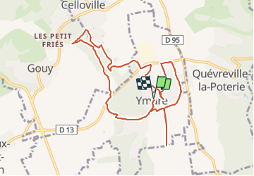

Length
10.1 km

Max alt
146 m

Uphill gradient
130 m
Km-Effort
11.9 km

Min alt
91 m

Downhill gradient
129 m
Boucle
Yes
Creation date :
2020-08-04 07:07:10.345
Updated on :
2021-07-18 22:22:26.274
2h43
Difficulty : Very easy

FREE GPS app for hiking
 SityTrail
IGN / Geographical institutes
SityTrail Plus
The world is yours!
About
Trail Walking of 10.1 km to be discovered at Normandy, Seine-Maritime, Ymare. This trail is proposed by MichelRando7656.
Description
Sentiers très variés. Bois et.campagne . Petits sentiers deville entre les haies.
Photos


Positioning
Country:
France
Region :
Normandy
Department/Province :
Seine-Maritime
Municipality :
Ymare
Location:
Unknown
Start:(Dec)
Start:(UTM)
367494 ; 5467934 (31U) N.
Comments