


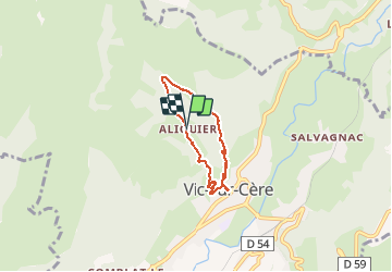
aliquier la croix

denel
User

Length
4.8 km

Max alt
986 m

Uphill gradient
302 m
Km-Effort
8.8 km

Min alt
685 m

Downhill gradient
298 m
Boucle
Yes
Creation date :
2020-08-04 07:47:18.405
Updated on :
2020-08-04 09:52:12.709
2h03
Difficulty : Easy

FREE GPS app for hiking
 SityTrail
IGN / Geographical institutes
SityTrail Plus
The world is yours!
About
Trail Walking of 4.8 km to be discovered at Auvergne-Rhône-Alpes, Cantal, Vic-sur-Cère. This trail is proposed by denel.
Description
Boucle à partir de aliquier
Positioning
Country:
France
Region :
Auvergne-Rhône-Alpes
Department/Province :
Cantal
Municipality :
Vic-sur-Cère
Location:
Unknown
Start:(Dec)
Start:(UTM)
469872 ; 4981569 (31T) N.
Comments