


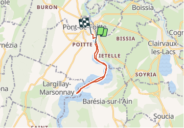
rando kayak lac Vanglans

choumac08
User

Length
8.4 km

Max alt
442 m

Uphill gradient
30 m
Km-Effort
8.8 km

Min alt
428 m

Downhill gradient
27 m
Boucle
No
Creation date :
2020-08-04 11:23:15.315
Updated on :
2020-08-04 13:02:33.449
1h38
Difficulty : Very easy

FREE GPS app for hiking
 SityTrail
IGN / Geographical institutes
SityTrail Plus
The world is yours!
About
Trail Canoe - kayak of 8.4 km to be discovered at Bourgogne-Franche-Comté, Jura, Pont-de-Poitte. This trail is proposed by choumac08.
Positioning
Country:
France
Region :
Bourgogne-Franche-Comté
Department/Province :
Jura
Municipality :
Pont-de-Poitte
Location:
Unknown
Start:(Dec)
Start:(UTM)
707017 ; 5161585 (31T) N.
Comments