


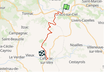
Cordes - cahuzac sur vere

Glurps
User

Length
17.7 km

Max alt
288 m

Uphill gradient
369 m
Km-Effort
23 km

Min alt
171 m

Downhill gradient
443 m
Boucle
No
Creation date :
2020-08-04 09:46:40.0
Updated on :
2020-08-04 15:27:37.06
4h54
Difficulty : Easy

FREE GPS app for hiking
 SityTrail
IGN / Geographical institutes
SityTrail Plus
The world is yours!
About
Trail Walking of 17.7 km to be discovered at Occitania, Tarn, Cordes-sur-Ciel. This trail is proposed by Glurps.
Description
Par le gr 46
Positioning
Country:
France
Region :
Occitania
Department/Province :
Tarn
Municipality :
Cordes-sur-Ciel
Location:
Unknown
Start:(Dec)
Start:(UTM)
415883 ; 4879511 (31T) N.
Comments