


2020-08-02 14:53:36

Blourouce
User

Length
19.4 km

Max alt
195 m

Uphill gradient
352 m
Km-Effort
24 km

Min alt
48 m

Downhill gradient
353 m
Boucle
Yes
Creation date :
2020-08-04 16:45:27.149
Updated on :
2020-08-04 16:47:16.055
5h12
Difficulty : Very difficult

FREE GPS app for hiking
 SityTrail
IGN / Geographical institutes
SityTrail Plus
The world is yours!
About
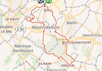
Trail Walking of 19.4 km to be discovered at Hauts-de-France, Pas-de-Calais, Ruitz. This trail is proposed by Blourouce.
Positioning
Country:
France
Region :
Hauts-de-France
Department/Province :
Pas-de-Calais
Municipality :
Ruitz
Location:
Unknown
Start:(Dec)
Start:(UTM)
470535 ; 5590879 (31U) N.
Comments