


Trois Ponts 20/20

fra_depoorter
User

Length
11.2 km

Max alt
350 m

Uphill gradient
267 m
Km-Effort
14.8 km

Min alt
229 m

Downhill gradient
266 m
Boucle
Yes
Creation date :
2020-08-05 08:00:24.49
Updated on :
2020-08-05 15:32:14.709
4h06
Difficulty : Very easy

FREE GPS app for hiking
 SityTrail
IGN / Geographical institutes
SityTrail Plus
The world is yours!
About
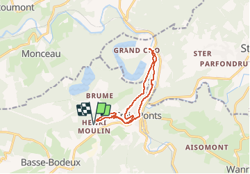
Trail Walking of 11.2 km to be discovered at Wallonia, Liège, Trois-Ponts. This trail is proposed by fra_depoorter.
Positioning
Country:
Belgium
Region :
Wallonia
Department/Province :
Liège
Municipality :
Trois-Ponts
Location:
Fosse
Start:(Dec)
Start:(UTM)
702544 ; 5583605 (31U) N.
Comments