


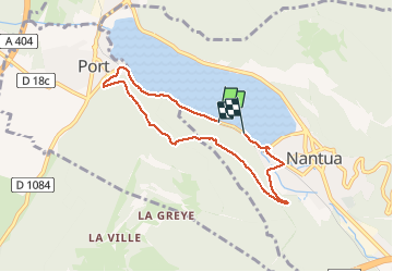
Nantua via roche du diable

janussity
User

Length
6.5 km

Max alt
752 m

Uphill gradient
324 m
Km-Effort
10.8 km

Min alt
476 m

Downhill gradient
333 m
Boucle
No
Creation date :
2020-08-05 13:46:33.917
Updated on :
2020-08-05 15:42:05.23
1h35
Difficulty : Medium

FREE GPS app for hiking
 SityTrail
IGN / Geographical institutes
SityTrail Plus
The world is yours!
About
Trail Walking of 6.5 km to be discovered at Auvergne-Rhône-Alpes, Ain, Nantua. This trail is proposed by janussity.
Description
Beau temps. montée du côté de Port et descente côté Nantua. Belles vues sur le lac
Photos


Positioning
Country:
France
Region :
Auvergne-Rhône-Alpes
Department/Province :
Ain
Municipality :
Nantua
Location:
Unknown
Start:(Dec)
Start:(UTM)
700043 ; 5114803 (31T) N.
Comments