


vvf vas de najac

Robertplessier
User
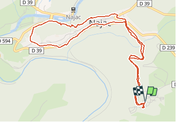

Length
6.9 km

Max alt
410 m

Uphill gradient
246 m
Km-Effort
10.2 km

Min alt
213 m

Downhill gradient
247 m
Boucle
Yes
Creation date :
2020-08-05 16:42:59.404
Updated on :
2020-08-05 17:27:44.733
44m
Difficulty : Very easy

FREE GPS app for hiking
 SityTrail
IGN / Geographical institutes
SityTrail Plus
The world is yours!
About
Trail Trail of 6.9 km to be discovered at Occitania, Aveyron, Najac. This trail is proposed by Robertplessier.
Description
raide, marche ds debut de remontee
cool
Positioning
Country:
France
Region :
Occitania
Department/Province :
Aveyron
Municipality :
Najac
Location:
Unknown
Start:(Dec)
Start:(UTM)
419220 ; 4895715 (31T) N.
Comments