


Anlier 1

dewaeph
User
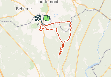

Length
10.9 km

Max alt
486 m

Uphill gradient
180 m
Km-Effort
13.3 km

Min alt
398 m

Downhill gradient
181 m
Boucle
Yes
Creation date :
2020-08-04 09:38:08.0
Updated on :
2020-08-05 21:06:53.862
4h25
Difficulty : Unknown

FREE GPS app for hiking
 SityTrail
IGN / Geographical institutes
SityTrail Plus
The world is yours!
About
Trail Walking of 10.9 km to be discovered at Wallonia, Luxembourg, Habay. This trail is proposed by dewaeph.
Description
Dans les bois
Positioning
Country:
Belgium
Region :
Wallonia
Department/Province :
Luxembourg
Municipality :
Habay
Location:
Anlier
Start:(Dec)
Start:(UTM)
688777 ; 5516611 (31U) N.
Comments