


Mont Clapier

domi06
User
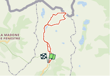

Length
14.3 km

Max alt
3023 m

Uphill gradient
1360 m
Km-Effort
32 km

Min alt
1684 m

Downhill gradient
1363 m
Boucle
Yes
Creation date :
2020-08-06 05:43:15.752
Updated on :
2020-08-13 14:09:36.035
9h39
Difficulty : Very difficult

FREE GPS app for hiking
 SityTrail
IGN / Geographical institutes
SityTrail Plus
The world is yours!
About
Trail Walking of 14.3 km to be discovered at Provence-Alpes-Côte d'Azur, Maritime Alps, Belvédère. This trail is proposed by domi06.
Photos


Positioning
Country:
France
Region :
Provence-Alpes-Côte d'Azur
Department/Province :
Maritime Alps
Municipality :
Belvédère
Location:
Unknown
Start:(Dec)
Start:(UTM)
371883 ; 4881323 (32T) N.
Comments