


CONCAR BCLE 16K

UDGI54
User
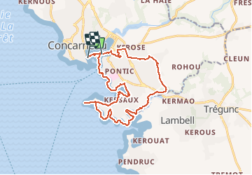

Length
16 km

Max alt
27 m

Uphill gradient
123 m
Km-Effort
17.6 km

Min alt
-3 m

Downhill gradient
120 m
Boucle
No
Creation date :
2020-08-09 07:52:05.854
Updated on :
2020-08-09 07:52:42.888
3h55
Difficulty : Difficult

FREE GPS app for hiking
 SityTrail
IGN / Geographical institutes
SityTrail Plus
The world is yours!
About
Trail Walking of 16 km to be discovered at Brittany, Finistère, Concarneau. This trail is proposed by UDGI54.
Positioning
Country:
France
Region :
Brittany
Department/Province :
Finistère
Municipality :
Concarneau
Location:
Unknown
Start:(Dec)
Start:(UTM)
431425 ; 5302407 (30T) N.
Comments