


Alpe d'Huez-Col de Sarenne-Auris

PhilippeC54
User
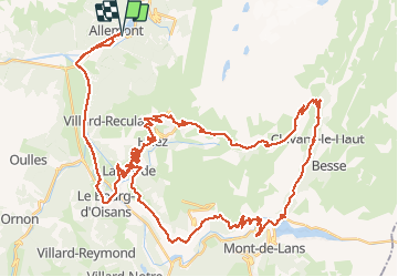

Length
76 km

Max alt
1995 m

Uphill gradient
2298 m
Km-Effort
107 km

Min alt
709 m

Downhill gradient
2298 m
Boucle
Yes
Creation date :
2020-08-11 06:05:34.814
Updated on :
2020-08-11 11:02:34.549
4h30
Difficulty : Difficult

FREE GPS app for hiking
 SityTrail
IGN / Geographical institutes
SityTrail Plus
The world is yours!
About
Trail Road bike of 76 km to be discovered at Auvergne-Rhône-Alpes, Isère, Allemond. This trail is proposed by PhilippeC54.
Positioning
Country:
France
Region :
Auvergne-Rhône-Alpes
Department/Province :
Isère
Municipality :
Allemond
Location:
Unknown
Start:(Dec)
Start:(UTM)
267351 ; 5001503 (32T) N.
Comments