


Savine

petergole
User
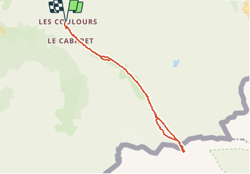

Length
15.9 km

Max alt
2492 m

Uphill gradient
436 m
Km-Effort
22 km

Min alt
2175 m

Downhill gradient
436 m
Boucle
Yes
Creation date :
2020-08-11 07:19:28.0
Updated on :
2020-08-12 10:11:05.711
6h53
Difficulty : Unknown

FREE GPS app for hiking
 SityTrail
IGN / Geographical institutes
SityTrail Plus
The world is yours!
About
Trail Walking of 15.9 km to be discovered at Auvergne-Rhône-Alpes, Savoy, Val-Cenis. This trail is proposed by petergole.
Positioning
Country:
France
Region :
Auvergne-Rhône-Alpes
Department/Province :
Savoy
Municipality :
Val-Cenis
Location:
Bramans
Start:(Dec)
Start:(UTM)
332432 ; 5008673 (32T) N.
Comments