


Sommet de la montagne de Robion 3542 OT

verotrail
User
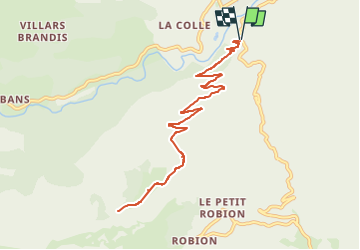

Length
12.1 km

Max alt
1642 m

Uphill gradient
934 m
Km-Effort
25 km

Min alt
725 m

Downhill gradient
934 m
Boucle
Yes
Creation date :
2020-08-12 13:19:19.906
Updated on :
2023-05-21 08:56:52.601
--
Difficulty : Difficult

FREE GPS app for hiking
 SityTrail
IGN / Geographical institutes
SityTrail Plus
The world is yours!
About
Trail On foot of 12.1 km to be discovered at Provence-Alpes-Côte d'Azur, Alpes-de-Haute-Provence, Castellane. This trail is proposed by verotrail.
Positioning
Country:
France
Region :
Provence-Alpes-Côte d'Azur
Department/Province :
Alpes-de-Haute-Provence
Municipality :
Castellane
Location:
Unknown
Start:(Dec)
Start:(UTM)
299038 ; 4856738 (32T) N.
Comments