


Prémanon, Mont Fier

MoiClaude
User
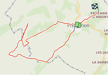

Length
10.9 km

Max alt
1296 m

Uphill gradient
355 m
Km-Effort
15.8 km

Min alt
1085 m

Downhill gradient
381 m
Boucle
No
Creation date :
2020-08-13 07:31:00.038
Updated on :
2020-08-13 11:57:57.732
2h34
Difficulty : Very easy

FREE GPS app for hiking
 SityTrail
IGN / Geographical institutes
SityTrail Plus
The world is yours!
About
Trail Walking of 10.9 km to be discovered at Bourgogne-Franche-Comté, Jura. This trail is proposed by MoiClaude.
Description
Superbe facile
Positioning
Country:
France
Region :
Bourgogne-Franche-Comté
Department/Province :
Jura
Municipality :
PREMANON
Location:
Unknown
Start:(Dec)
Start:(UTM)
271785 ; 5149373 (32T) N.
Comments
beaucoup trop de grandes pistes et de routes en plein soleil. on a beaucoup mieux aux alentours
Superbe Rando