


Bressans Lanslevillard

petergole
User
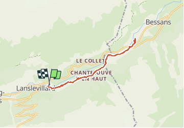

Length
15.3 km

Max alt
1796 m

Uphill gradient
472 m
Km-Effort
22 km

Min alt
1481 m

Downhill gradient
460 m
Boucle
Yes
Creation date :
2020-08-13 08:17:04.0
Updated on :
2020-08-13 15:22:18.884
7h04
Difficulty : Unknown

FREE GPS app for hiking
 SityTrail
IGN / Geographical institutes
SityTrail Plus
The world is yours!
About
Trail Walking of 15.3 km to be discovered at Auvergne-Rhône-Alpes, Savoy, Val-Cenis. This trail is proposed by petergole.
Positioning
Country:
France
Region :
Auvergne-Rhône-Alpes
Department/Province :
Savoy
Municipality :
Val-Cenis
Location:
Lanslevillard
Start:(Dec)
Start:(UTM)
336938 ; 5017314 (32T) N.
Comments