


Gournier-Châteauneuf 10km

thonyc
User GUIDE
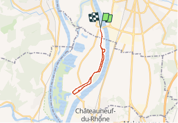

Length
9.4 km

Max alt
84 m

Uphill gradient
64 m
Km-Effort
10.3 km

Min alt
62 m

Downhill gradient
64 m
Boucle
Yes
Creation date :
2020-08-14 14:39:33.035
Updated on :
2020-08-18 06:48:21.21
1h27
Difficulty : Easy

FREE GPS app for hiking
 SityTrail
IGN / Geographical institutes
SityTrail Plus
The world is yours!
About
Trail Walking of 9.4 km to be discovered at Auvergne-Rhône-Alpes, Drôme, Montélimar. This trail is proposed by thonyc.
Photos


Positioning
Country:
France
Region :
Auvergne-Rhône-Alpes
Department/Province :
Drôme
Municipality :
Montélimar
Location:
Unknown
Start:(Dec)
Start:(UTM)
636878 ; 4932619 (31T) N.
Comments