


st esteve

babouille
User
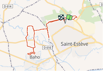

Length
14.6 km

Max alt
75 m

Uphill gradient
115 m
Km-Effort
16.1 km

Min alt
49 m

Downhill gradient
115 m
Boucle
Yes
Creation date :
2020-08-15 05:21:53.461
Updated on :
2020-08-15 07:23:25.244
1h46
Difficulty : Very easy

FREE GPS app for hiking
 SityTrail
IGN / Geographical institutes
SityTrail Plus
The world is yours!
About
Trail Running of 14.6 km to be discovered at Occitania, Pyrénées-Orientales, Saint-Estève. This trail is proposed by babouille.
Positioning
Country:
France
Region :
Occitania
Department/Province :
Pyrénées-Orientales
Municipality :
Saint-Estève
Location:
Unknown
Start:(Dec)
Start:(UTM)
486918 ; 4729632 (31T) N.
Comments