


16-08

DaVinci
User

Length
14.8 km

Max alt
99 m

Uphill gradient
53 m
Km-Effort
15.5 km

Min alt
85 m

Downhill gradient
59 m
Boucle
No
Creation date :
2020-08-16 08:01:27.248
Updated on :
2020-08-16 10:46:34.947
2h44
Difficulty : Very easy

FREE GPS app for hiking
 SityTrail
IGN / Geographical institutes
SityTrail Plus
The world is yours!
About
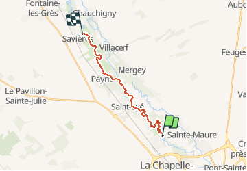
Trail Canoe - kayak of 14.8 km to be discovered at Grand Est, Aube, Barberey-Saint-Sulpice. This trail is proposed by DaVinci.
Positioning
Country:
France
Region :
Grand Est
Department/Province :
Aube
Municipality :
Barberey-Saint-Sulpice
Location:
Unknown
Start:(Dec)
Start:(UTM)
576807 ; 5354786 (31U) N.
Comments