


lac nire

jlgott
User
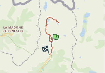

Length
11.7 km

Max alt
2367 m

Uphill gradient
632 m
Km-Effort
20 km

Min alt
1686 m

Downhill gradient
719 m
Boucle
No
Creation date :
2020-08-16 08:13:00.613
Updated on :
2020-08-16 14:49:01.539
5h39
Difficulty : Medium

FREE GPS app for hiking
 SityTrail
IGN / Geographical institutes
SityTrail Plus
The world is yours!
About
Trail Walking of 11.7 km to be discovered at Provence-Alpes-Côte d'Azur, Maritime Alps, Belvédère. This trail is proposed by jlgott.
Positioning
Country:
France
Region :
Provence-Alpes-Côte d'Azur
Department/Province :
Maritime Alps
Municipality :
Belvédère
Location:
Unknown
Start:(Dec)
Start:(UTM)
372067 ; 4882339 (32T) N.
Comments