crêtes de bouc

ja.13061965
User
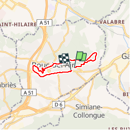

Length
9.6 km

Max alt
326 m

Uphill gradient
200 m
Km-Effort
12.3 km

Min alt
171 m

Downhill gradient
205 m
Boucle
Yes
Creation date :
2019-06-20 09:33:05.5
Updated on :
2019-06-20 09:33:05.754
2h31
Difficulty : Easy

FREE GPS app for hiking
 SityTrail
IGN / Geographical institutes
SityTrail Plus
The world is yours!
About
Trail Walking of 9.6 km to be discovered at Provence-Alpes-Côte d'Azur, Bouches-du-Rhône, Bouc-Bel-Air. This trail is proposed by ja.13061965.
Positioning
Country:
France
Region :
Provence-Alpes-Côte d'Azur
Department/Province :
Bouches-du-Rhône
Municipality :
Bouc-Bel-Air
Location:
Unknown
Start:(Dec)
Start:(UTM)
696399 ; 4813630 (31T) N.
Comments