


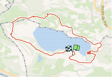
lac de lourdes

CABERMAT
User

Length
6.9 km

Max alt
474 m

Uphill gradient
109 m
Km-Effort
8.3 km

Min alt
427 m

Downhill gradient
108 m
Boucle
Yes
Creation date :
2020-08-19 10:40:31.973
Updated on :
2020-08-19 13:29:57.848
1h40
Difficulty : Very easy

FREE GPS app for hiking
 SityTrail
IGN / Geographical institutes
SityTrail Plus
The world is yours!
About
Trail Walking of 6.9 km to be discovered at Occitania, Hautespyrenees, Lourdes. This trail is proposed by CABERMAT.
Photos

Positioning
Country:
France
Region :
Occitania
Department/Province :
Hautespyrenees
Municipality :
Lourdes
Location:
Unknown
Start:(Dec)
Start:(UTM)
737366 ; 4776674 (30T) N.
Comments