


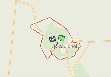
chemin des pâtures de Locquignol

BrassensJC
User

Length
7.6 km

Max alt
182 m

Uphill gradient
97 m
Km-Effort
8.9 km

Min alt
154 m

Downhill gradient
96 m
Boucle
Yes
Creation date :
2020-08-12 12:48:54.774
Updated on :
2020-08-20 08:18:23.32
1h55
Difficulty : Easy

FREE GPS app for hiking
 SityTrail
IGN / Geographical institutes
SityTrail Plus
The world is yours!
About
Trail Walking of 7.6 km to be discovered at Hauts-de-France, Nord, Locquignol. This trail is proposed by BrassensJC.
Photos

Positioning
Country:
France
Region :
Hauts-de-France
Department/Province :
Nord
Municipality :
Locquignol
Location:
Unknown
Start:(Dec)
Start:(UTM)
550837 ; 5561022 (31U) N.
Comments
Super randonnée, le début est pénible dur des laies ravagées par la surexploitation de mormal.