


Chamrousse - L'Arselle

maupassant38
User
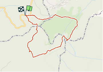

Length
4.9 km

Max alt
1645 m

Uphill gradient
109 m
Km-Effort
6.3 km

Min alt
1590 m

Downhill gradient
110 m
Boucle
Yes
Creation date :
2020-08-20 09:46:07.468
Updated on :
2020-08-20 12:10:14.038
1h08
Difficulty : Easy

FREE GPS app for hiking
 SityTrail
IGN / Geographical institutes
SityTrail Plus
The world is yours!
About
Trail Walking of 4.9 km to be discovered at Auvergne-Rhône-Alpes, Isère, Vaulnaveys-le-Haut. This trail is proposed by maupassant38.
Positioning
Country:
France
Region :
Auvergne-Rhône-Alpes
Department/Province :
Isère
Municipality :
Vaulnaveys-le-Haut
Location:
Unknown
Start:(Dec)
Start:(UTM)
725722 ; 4998011 (31T) N.
Comments