


Chopine et Chaumont

Gegetop
User
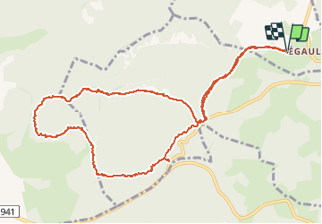

Length
12.3 km

Max alt
1092 m

Uphill gradient
294 m
Km-Effort
16.2 km

Min alt
818 m

Downhill gradient
294 m
Boucle
Yes
Creation date :
2020-08-21 08:44:09.744
Updated on :
2020-08-21 12:14:38.294
3h00
Difficulty : Very easy
2h46
Difficulty : Medium

FREE GPS app for hiking
 SityTrail
IGN / Geographical institutes
SityTrail Plus
The world is yours!
About
Trail Walking of 12.3 km to be discovered at Auvergne-Rhône-Alpes, Puy-de-Dôme, Volvic. This trail is proposed by Gegetop.
Description
Départ chemin des cabanes à Egaules.
Photos

Positioning
Country:
France
Region :
Auvergne-Rhône-Alpes
Department/Province :
Puy-de-Dôme
Municipality :
Volvic
Location:
Unknown
Start:(Dec)
Start:(UTM)
500037 ; 5075930 (31T) N.
Comments