


Le Mas , L'Arpille aller retour 3542 ET

verotrail
User
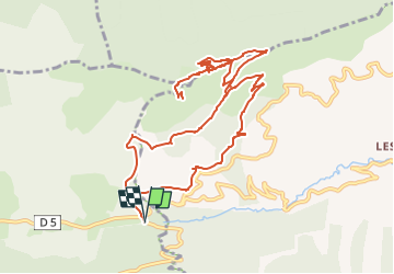

Length
13.9 km

Max alt
1674 m

Uphill gradient
600 m
Km-Effort
22 km

Min alt
1132 m

Downhill gradient
601 m
Boucle
Yes
Creation date :
2020-08-21 18:55:56.623
Updated on :
2022-11-15 13:46:07.658
--
Difficulty : Medium

FREE GPS app for hiking
 SityTrail
IGN / Geographical institutes
SityTrail Plus
The world is yours!
About
Trail On foot of 13.9 km to be discovered at Provence-Alpes-Côte d'Azur, Maritime Alps, Saint-Auban. This trail is proposed by verotrail.
Positioning
Country:
France
Region :
Provence-Alpes-Côte d'Azur
Department/Province :
Maritime Alps
Municipality :
Saint-Auban
Location:
Unknown
Start:(Dec)
Start:(UTM)
323058 ; 4854832 (32T) N.
Comments