


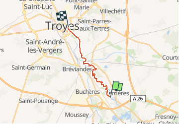
verrieres

DaVinci
User

Length
12.7 km

Max alt
116 m

Uphill gradient
60 m
Km-Effort
13.5 km

Min alt
102 m

Downhill gradient
69 m
Boucle
No
Creation date :
2020-08-22 12:51:10.496
Updated on :
2020-08-22 15:16:37.052
2h24
Difficulty : Very easy

FREE GPS app for hiking
 SityTrail
IGN / Geographical institutes
SityTrail Plus
The world is yours!
About
Trail Canoe - kayak of 12.7 km to be discovered at Grand Est, Aube, Verrières. This trail is proposed by DaVinci.
Positioning
Country:
France
Region :
Grand Est
Department/Province :
Aube
Municipality :
Verrières
Location:
Unknown
Start:(Dec)
Start:(UTM)
584799 ; 5342603 (31U) N.
Comments