boucles des sommets de Trois-Ponts

bastinbe
User
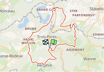

Length
19.3 km

Max alt
458 m

Uphill gradient
749 m
Km-Effort
29 km

Min alt
233 m

Downhill gradient
754 m
Boucle
Yes
Creation date :
2020-08-23 16:54:21.466
Updated on :
2020-08-23 17:11:09.413
5h00
Difficulty : Difficult

FREE GPS app for hiking
 SityTrail
IGN / Geographical institutes
SityTrail Plus
The world is yours!
About
Trail On foot of 19.3 km to be discovered at Wallonia, Liège, Trois-Ponts. This trail is proposed by bastinbe.
Description
randonnée au départ du parking de la piscine de Trois-Ponts
Positioning
Country:
Belgium
Region :
Wallonia
Department/Province :
Liège
Municipality :
Trois-Ponts
Location:
Fosse
Start:(Dec)
Start:(UTM)
704394 ; 5583017 (31U) N.
Comments