


Valbonnais - Le Canal - Antraigues

maupassant38
User
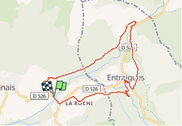

Length
10.6 km

Max alt
852 m

Uphill gradient
225 m
Km-Effort
13.6 km

Min alt
737 m

Downhill gradient
228 m
Boucle
Yes
Creation date :
2020-08-25 08:20:11.453
Updated on :
2020-09-06 16:02:41.152
2h25
Difficulty : Easy

FREE GPS app for hiking
 SityTrail
IGN / Geographical institutes
SityTrail Plus
The world is yours!
About
Trail Walking of 10.6 km to be discovered at Auvergne-Rhône-Alpes, Isère, Valbonnais. This trail is proposed by maupassant38.
Positioning
Country:
France
Region :
Auvergne-Rhône-Alpes
Department/Province :
Isère
Municipality :
Valbonnais
Location:
Unknown
Start:(Dec)
Start:(UTM)
730924 ; 4975757 (31T) N.
Comments