


Valbonnais - Pont des Fayettes

maupassant38
User
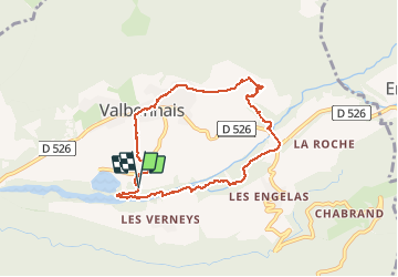

Length
7.6 km

Max alt
864 m

Uphill gradient
173 m
Km-Effort
9.9 km

Min alt
706 m

Downhill gradient
169 m
Boucle
Yes
Creation date :
2020-08-26 07:49:18.982
Updated on :
2020-08-26 10:06:44.654
1h43
Difficulty : Easy

FREE GPS app for hiking
 SityTrail
IGN / Geographical institutes
SityTrail Plus
The world is yours!
About
Trail Walking of 7.6 km to be discovered at Auvergne-Rhône-Alpes, Isère, Valbonnais. This trail is proposed by maupassant38.
Positioning
Country:
France
Region :
Auvergne-Rhône-Alpes
Department/Province :
Isère
Municipality :
Valbonnais
Location:
Unknown
Start:(Dec)
Start:(UTM)
729336 ; 4974995 (31T) N.
Comments