Passerelle

PhilippeC54
User

Length
9.8 km

Max alt
575 m

Uphill gradient
315 m
Km-Effort
14 km

Min alt
487 m

Downhill gradient
317 m
Boucle
Yes
Creation date :
2020-08-27 06:42:21.819
Updated on :
2020-08-27 09:29:59.825
2h24
Difficulty : Easy

FREE GPS app for hiking
 SityTrail
IGN / Geographical institutes
SityTrail Plus
The world is yours!
About
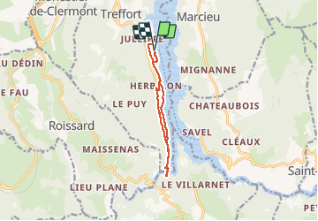
Trail Walking of 9.8 km to be discovered at Auvergne-Rhône-Alpes, Isère, Treffort. This trail is proposed by PhilippeC54.
Positioning
Country:
France
Region :
Auvergne-Rhône-Alpes
Department/Province :
Isère
Municipality :
Treffort
Location:
Unknown
Start:(Dec)
Start:(UTM)
710919 ; 4975923 (31T) N.
Comments