


SityTrail - Pyrénées Orientales 1

tgvpatrickfavre
User
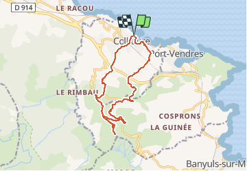

Length
15.3 km

Max alt
637 m

Uphill gradient
716 m
Km-Effort
25 km

Min alt
4 m

Downhill gradient
716 m
Boucle
Yes
Creation date :
2020-08-28 15:11:51.167
Updated on :
2020-08-28 15:51:28.01

FREE GPS app for hiking
 SityTrail
IGN / Geographical institutes
SityTrail Plus
The world is yours!
About
Trail of 15.3 km to be discovered at Occitania, Pyrénées-Orientales, Collioure. This trail is proposed by tgvpatrickfavre.
Description
1. Col d'en Piques - 90m
2. Col de Rousse- - 135m


Positioning
Country:
France
Region :
Occitania
Department/Province :
Pyrénées-Orientales
Municipality :
Collioure
Location:
Unknown
Start:(Dec)
Start:(UTM)
506941 ; 4708241 (31T) N.
Comments