


daverdisse 250820

guyernage25
User
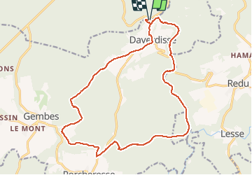

Length
19 km

Max alt
418 m

Uphill gradient
398 m
Km-Effort
24 km

Min alt
227 m

Downhill gradient
398 m
Boucle
Yes
Creation date :
2020-08-25 06:16:24.963
Updated on :
2020-08-29 09:30:05.198
4h22
Difficulty : Medium

FREE GPS app for hiking
 SityTrail
IGN / Geographical institutes
SityTrail Plus
The world is yours!
About
Trail Walking of 19 km to be discovered at Wallonia, Luxembourg, Wellin. This trail is proposed by guyernage25.
Description
belle balade forestiere en partie le long de la lesse
Positioning
Country:
Belgium
Region :
Wallonia
Department/Province :
Luxembourg
Municipality :
Wellin
Location:
Halma
Start:(Dec)
Start:(UTM)
651612 ; 5543871 (31U) N.
Comments