


Refuge des Artigus

c.chehere
User
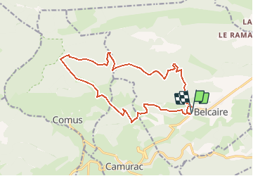

Length
17.6 km

Max alt
1482 m

Uphill gradient
734 m
Km-Effort
27 km

Min alt
1032 m

Downhill gradient
733 m
Boucle
Yes
Creation date :
2020-08-29 09:41:31.545
Updated on :
2020-08-29 09:43:57.794
5h40
Difficulty : Difficult

FREE GPS app for hiking
 SityTrail
IGN / Geographical institutes
SityTrail Plus
The world is yours!
About
Trail Walking of 17.6 km to be discovered at Occitania, Aude, Belcaire. This trail is proposed by c.chehere.
Description
Se garer sur le parking du camping a l'entrées de Belcaire
Positioning
Country:
France
Region :
Occitania
Department/Province :
Aude
Municipality :
Belcaire
Location:
Unknown
Start:(Dec)
Start:(UTM)
414251 ; 4740936 (31T) N.
Comments