


tempo velorail

adye
User
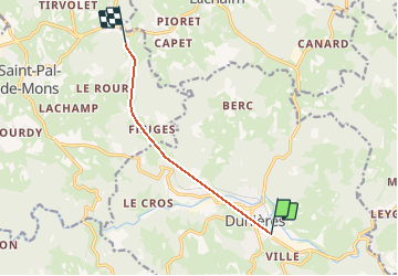

Length
6.4 km

Max alt
901 m

Uphill gradient
300 m
Km-Effort
10.1 km

Min alt
744 m

Downhill gradient
226 m
Boucle
No
Creation date :
2020-08-21 12:02:34.702
Updated on :
2020-08-29 10:09:52.396
3m
Difficulty : Easy

FREE GPS app for hiking
 SityTrail
IGN / Geographical institutes
SityTrail Plus
The world is yours!
About
Trail Mountain bike of 6.4 km to be discovered at Auvergne-Rhône-Alpes, Haute-Loire, Dunières. This trail is proposed by adye.
Positioning
Country:
France
Region :
Auvergne-Rhône-Alpes
Department/Province :
Haute-Loire
Municipality :
Dunières
Location:
Unknown
Start:(Dec)
Start:(UTM)
605974 ; 5007385 (31T) N.
Comments