


boucle Trois-ponts / Aisomont / Long-Prés /

bastinbe
User
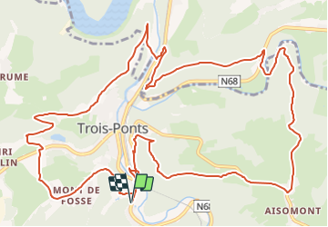

Length
15.7 km

Max alt
448 m

Uphill gradient
550 m
Km-Effort
23 km

Min alt
240 m

Downhill gradient
550 m
Boucle
Yes
Creation date :
2020-08-29 16:21:24.315
Updated on :
2021-05-26 16:55:51.236
4h00
Difficulty : Difficult

FREE GPS app for hiking
 SityTrail
IGN / Geographical institutes
SityTrail Plus
The world is yours!
About
Trail On foot of 15.7 km to be discovered at Wallonia, Liège, Trois-Ponts. This trail is proposed by bastinbe.
Positioning
Country:
Belgium
Region :
Wallonia
Department/Province :
Liège
Municipality :
Trois-Ponts
Location:
Unknown
Start:(Dec)
Start:(UTM)
704391 ; 5583015 (31U) N.
Comments