


Col de la Béne

c.chehere
User

Length
10.7 km

Max alt
1426 m

Uphill gradient
570 m
Km-Effort
18.3 km

Min alt
867 m

Downhill gradient
575 m
Boucle
Yes
Creation date :
2020-08-31 05:26:59.259
Updated on :
2020-10-01 16:41:08.263
5h26
Difficulty : Very difficult

FREE GPS app for hiking
 SityTrail
IGN / Geographical institutes
SityTrail Plus
The world is yours!
About
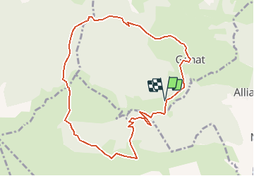
Trail Walking of 10.7 km to be discovered at Occitania, Ariège, Génat. This trail is proposed by c.chehere.
Description
Parking au lieu-dit la grangette d'en bas commune de Génat
Descriptif dans visiorando.
Nombreux déchets de coupe forestiere entre Génat et le col de Lastris
Positioning
Country:
France
Region :
Occitania
Department/Province :
Ariège
Municipality :
Génat
Location:
Unknown
Start:(Dec)
Start:(UTM)
382833 ; 4741381 (31T) N.
Comments