


Molière sur ceze

Dupuybadonniere
User
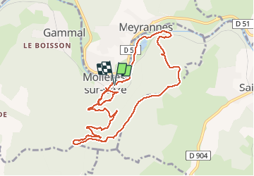

Length
11.2 km

Max alt
423 m

Uphill gradient
335 m
Km-Effort
15.6 km

Min alt
141 m

Downhill gradient
335 m
Boucle
Yes
Creation date :
2020-08-30 11:56:07.805
Updated on :
2020-08-31 08:59:40.405
4h26
Difficulty : Very easy

FREE GPS app for hiking
 SityTrail
IGN / Geographical institutes
SityTrail Plus
The world is yours!
About
Trail Walking of 11.2 km to be discovered at Occitania, Gard, Molières-sur-Cèze. This trail is proposed by Dupuybadonniere.
Positioning
Country:
France
Region :
Occitania
Department/Province :
Gard
Municipality :
Molières-sur-Cèze
Location:
Unknown
Start:(Dec)
Start:(UTM)
592661 ; 4901445 (31T) N.
Comments