


Tour engins-sornin molliere

trailer38
User
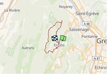

Length
17.7 km

Max alt
1715 m

Uphill gradient
915 m
Km-Effort
30 km

Min alt
930 m

Downhill gradient
951 m
Boucle
Yes
Creation date :
2020-08-31 09:37:46.955
Updated on :
2020-08-31 09:38:46.952
--
Difficulty : Very easy

FREE GPS app for hiking
 SityTrail
IGN / Geographical institutes
SityTrail Plus
The world is yours!
About
Trail Trail of 17.7 km to be discovered at Auvergne-Rhône-Alpes, Isère, Engins. This trail is proposed by trailer38.
Positioning
Country:
France
Region :
Auvergne-Rhône-Alpes
Department/Province :
Isère
Municipality :
Engins
Location:
Unknown
Start:(Dec)
Start:(UTM)
705529 ; 5006408 (31T) N.
Comments