


milau

jacquesduchesne
User
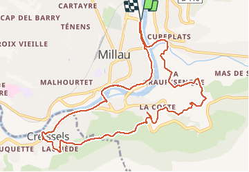

Length
12.6 km

Max alt
519 m

Uphill gradient
320 m
Km-Effort
16.9 km

Min alt
353 m

Downhill gradient
319 m
Boucle
Yes
Creation date :
2020-09-01 08:18:36.118
Updated on :
2020-09-01 11:24:00.719
2h46
Difficulty : Very easy

FREE GPS app for hiking
 SityTrail
IGN / Geographical institutes
SityTrail Plus
The world is yours!
About
Trail Walking of 12.6 km to be discovered at Occitania, Aveyron, Millau. This trail is proposed by jacquesduchesne.
Positioning
Country:
France
Region :
Occitania
Department/Province :
Aveyron
Municipality :
Millau
Location:
Unknown
Start:(Dec)
Start:(UTM)
506766 ; 4883743 (31T) N.
Comments