


goupillieres

semaine
User
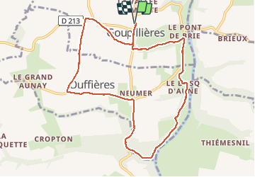

Length
9.5 km

Max alt
167 m

Uphill gradient
189 m
Km-Effort
12 km

Min alt
19 m

Downhill gradient
189 m
Boucle
Yes
Creation date :
2020-09-02 12:06:18.686
Updated on :
2020-09-02 15:02:09.052
2h55
Difficulty : Very easy

FREE GPS app for hiking
 SityTrail
IGN / Geographical institutes
SityTrail Plus
The world is yours!
About
Trail Walking of 9.5 km to be discovered at Normandy, Calvados, Montillières-sur-Orne. This trail is proposed by semaine.
Positioning
Country:
France
Region :
Normandy
Department/Province :
Calvados
Municipality :
Montillières-sur-Orne
Location:
Unknown
Start:(Dec)
Start:(UTM)
684223 ; 5434308 (30U) N.
Comments