


suarlee

sarriette
User
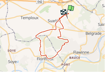

Length
14.3 km

Max alt
211 m

Uphill gradient
203 m
Km-Effort
17 km

Min alt
88 m

Downhill gradient
208 m
Boucle
No
Creation date :
2020-09-03 11:56:35.759
Updated on :
2020-09-03 14:59:34.004
2h41
Difficulty : Medium

FREE GPS app for hiking
 SityTrail
IGN / Geographical institutes
SityTrail Plus
The world is yours!
About
Trail Walking of 14.3 km to be discovered at Wallonia, Namur, Namur. This trail is proposed by sarriette.
Positioning
Country:
Belgium
Region :
Wallonia
Department/Province :
Namur
Municipality :
Namur
Location:
Suarlée
Start:(Dec)
Start:(UTM)
627363 ; 5594128 (31U) N.
Comments