


Ronde van st pietersberg

stef789
User GUIDE
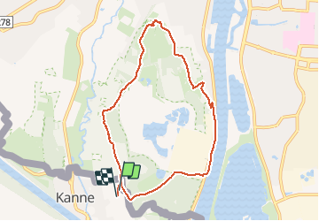

Length
7.4 km

Max alt
102 m

Uphill gradient
146 m
Km-Effort
9.4 km

Min alt
44 m

Downhill gradient
150 m
Boucle
Yes
Creation date :
2020-09-05 12:19:12.629
Updated on :
2020-09-05 14:19:32.495
1h59
Difficulty : Very easy

FREE GPS app for hiking
 SityTrail
IGN / Geographical institutes
SityTrail Plus
The world is yours!
About
Trail Walking of 7.4 km to be discovered at Flanders, Limburg, Riemst. This trail is proposed by stef789.
Positioning
Country:
Belgium
Region :
Flanders
Department/Province :
Limburg
Municipality :
Riemst
Location:
Kanne
Start:(Dec)
Start:(UTM)
688633 ; 5632680 (31U) N.
Comments