


Du mont dol a Dol

eric.deniau
User
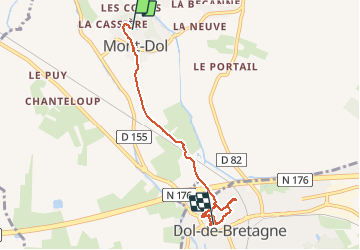

Length
5.1 km

Max alt
60 m

Uphill gradient
45 m
Km-Effort
5.8 km

Min alt
-1 m

Downhill gradient
86 m
Boucle
No
Creation date :
2020-09-06 07:40:48.0
Updated on :
2020-09-06 10:14:53.882
2h34
Difficulty : Unknown

FREE GPS app for hiking
 SityTrail
IGN / Geographical institutes
SityTrail Plus
The world is yours!
About
Trail Walking of 5.1 km to be discovered at Brittany, Ille-et-Vilaine, Mont-Dol. This trail is proposed by eric.deniau.
Positioning
Country:
France
Region :
Brittany
Department/Province :
Ille-et-Vilaine
Municipality :
Mont-Dol
Location:
Unknown
Start:(Dec)
Start:(UTM)
590823 ; 5380615 (30U) N.
Comments